By Gonzalo Navarrete Muñoz, Historian of Mérida
Translation by Mary Maas.
The presentation that Gonzalo Navarrete Muñoz, historian of Mérida, imparted January 5 2013 at the Olimpo auditorium, in honor of the 464th anniversary celebration of the founding of Mérida, Yucatan.
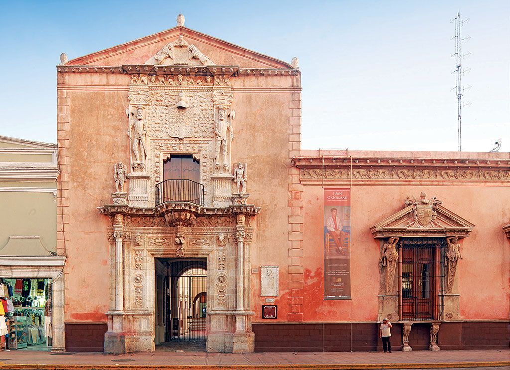
Casa de Montejo, the house of Montejo, founder of Merida.
Like an Emirate of Spain in Yucatán
Diego Velásquez was a greedy and intriguing man who claimed the privilege of “fruitful use” for whatever territory he discovered, and to whom was given Santa María de los Remedios, today known as Yucatán.
It was he who told the king Carlos V about the existence of this new discovery; he also dared to claim that he had made converts in those splendid lands. Based on this information, Pope Leo X declared, in 1519: “With the Apostolic Authority and by the means of the following charters, we erect for now and in perpetuity in the city that will be called Carolina in the pueblo or region of the island of the Holy Virgin of Remedies….”.
This city, founded by don Francisco de Montejo over the ancient Ichanzihó was given the name “Carolina”, which vanished to be replaced by Mérida, seat of the civil and military powers of the province of Yucatán. Why was Mérida in this geographic location since it was not a port or close to a river? In Yucatán, the Spanish conquerors found two Maya tribes that were their most faithful allies: the Xius and the Peches. In the region of the latter, Montejo found the best hospitality for his second entrance to Yucatán.
It’s necessary to make the point that the two tribes had a common enemy, which spurred them to ally themselves with the foreigners: the Cocomes.
Now for what is known: this is a frequent passage in the story of the conquest of all Mexico. It is here that the son of Montejo would found the capital city, in an old settlement near the territory of the Peches.
There were around a thousand Mayas who lived in “the city of the five hills”.
Having founded the city, the Spanish erected it in the area contained between two hills, leaving the more distant territories for the Indians.
So, the conquistadores planned the city with the classic rectangular formula, and divided it into blocks among the 115 first residents.
The buildings and hills evoked the august Emirate of Spain, for which the splendid city was named: Mérida. The Spanish were looked upon well in the surrounding areas: the local chiefs of the pueblos of Caucel and Itzimná celebrated them and even asked to be baptized, which was the stated goal of the conquest, according to the papal concessions.
The neighborhoods of Santiago, Santa Catarina, San Sebastián and San Cristóbal had their own governments; but they were not entrusted with the Indians and their tribute – inevitably, and as a consequence of domination – the Indians paid them directly to the Royal treasury. Their activities were those of the “naboríos” or indigenous people dedicated to domestic labor with payment for their work.
There was another neighborhood established to the north of the city, Santa Lucía. It was in the 17th century that the neighborhood of Santa Ana began to develop to the north, further from the old city plan.
The city grew and the Creole population extended to the walls of the city, but no further than that. Until then the relations with the Indian neighborhood were taken care of by the Tribunal of Indians, which served as their protector and defender.
As a manifestation of the true talent of the Spanish to maintain their empire, one needs to add a little-mentioned detail: in the parish archives one can note that there were Indians who used titles of noblemen, with all the merits (prestancia) of a Castilian gentleman.
Division by Castes
Since the 18th century until the end of the 19th, the city of Mérida was contained within the old neighborhoods and their surroundings: San Cristóbal, La Mejorada, San Juan, San Sebastián, la Ermita de Santa Isabel, Santiago, and Santa Ana. During the colonial era, the parishes were divided by castes: the Sacred Cathedral, for Spanish or whites; that of the Holy Name of Jesus for the blacks or browns, as well as the Hermitage of Santa Lucía, that of Santiago for the Indians of the neighborhood and servants of the Spanish, and that of Guadalupe or San Cristóbal, for the Indians outside the city.
It should be clarified that during the long history of our city there have been three forms of street names:
The first dates from the times of the first empire and was based on two axial streets: 60 from north to south and 61 from east to west; from here were derived the streets 1st, 2nd, 3rd, etcetera.
The second was based on giving the streets names of distinguished people: The Alley of Cabo Piña (currently the Alley of the Congress); Rivero street, Regil Estrada street, Sierra O”Reilly street, Cepeda Peraza street, among many others; this happened during the governorship of don José María Iturralde.
And the third, which is the one that remains, came into being during the governorship of Licenciado Carlos Peón Machado.
Also, one has to mention our ancestral and evocative way of naming the street corners, a very old custom, that did not extend to the rest of the city when it broke through the four cardinal points.
Go to next part: THE OLD NEIGHBOURHOODS OF MERIDA: SANTIAGO (Tomorrow)


