
I look up at Mount Blue Sky every single day. It’s the most prominent mountain on the horizon from where we live in the Denver area.
I stood atop it once. Three years back, we drove to the summit with my sea-level-dwelling in-laws so they could experience Colorado from an elevation of 14,268 feet (4349 m). There is a paved highway that stops just shy of the top. From there, it’s a relatively short walk to the summit. I know plenty of people get all up in arms about the fact that you can drive up the mountain, but I appreciate the accessibility of it. Not everyone is able to hike, and this provides a way for them to experience the high elevation environment.
We had a beautiful sunny day, with lots of wildlife (Mount Blue Sky is home to bighorn sheep and mountain goats), very little wind, and excellent visibility. Truly, it was the best summit experience we could have asked for.


Despite this experience, though, I wanted to actually climb the mountain. I wanted to be able to stand on the summit and look down at where I live, and then arrive home and look up at Mount Blue Sky with the knowledge that I hiked to the summit with my own two feet. In August 2022, I finally did.
Due to heavy use and limited parking, you must have a timed entry permit to drive the Mount Blue Sky Highway to the summit. Permits must be purchased in advance; 75% are released 30 days prior while the remaining 25% are released two days in advance. I had no trouble getting a permit… something that is highly unusual in Colorado. I reserved one two days in advance, about four hours after they went on sale, and there were still plenty left. The permits are good for three days, which allowed me some flexibility to plan around the weather.
There are different parking locations on Mount Blue Sky, and you should purchase the permit that aligns with what you want to see. I purchased the all-inclusive permit, as I would be parking at Summit Lake to start my hike but wanted to make other stops as well.
Also: note that there is no phone service at the entrance. You must download/screenshot your entry ticket in advance so they can scan it at the gate. If you arrive prior to 8:00am, the entrance station will not be staffed; you must display a printed copy of your 8:00am reservation on your dashboard, along with your America the Beautiful Pass, if applicable.
Anyway. I arrived at the byway entrance around 5:30am and began the harrowing 9 mile (14.5 km) drive to Summit Lake. The road is paved the entire way, although in places the pavement is severely warped. Nonetheless, my sedan made it up with no issue. That being said, the road is also extremely curvy and narrow, with a complete lack of shoulders and guard rails. It’s just the road… and then the edge of the mountain. The views are spectacular, but if you’re afraid of heights or exposure, this is absolutely not the drive for you. I’m not afraid of heights or exposure, but when I was driving myself to the trailhead, I was terrified. I hated every second of it.

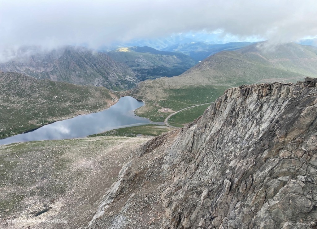
Summit Lake sits at an elevation of about 12,800 ft (3900 m). I arrived at the lake slightly before 6:00am, just in time for a colorful sunrise. The wind was gusty and cold, and I was not looking forward to that aspect of the day. Luckily, it died down as the sun rose. In fact, the rest of the day ended up being unusually calm.


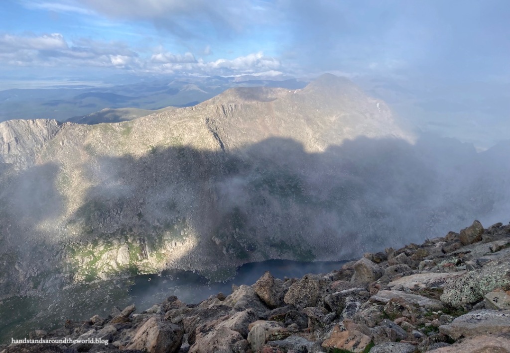
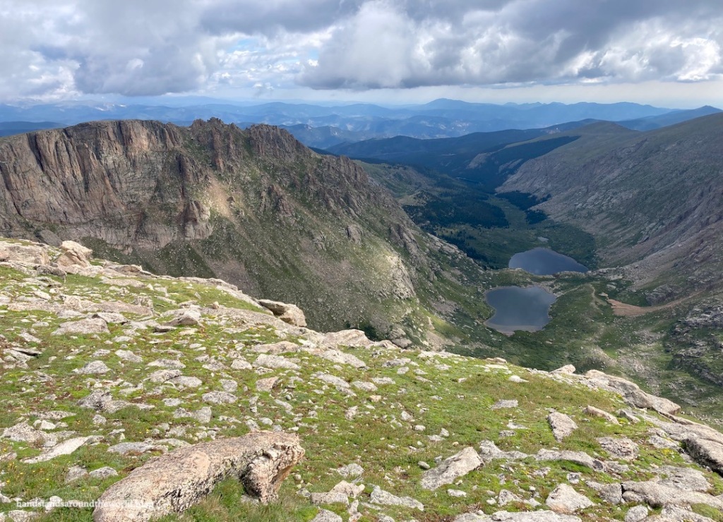
From the trailhead at Summit Lake, I followed the path to the north, around the lake to the Chicago Lakes Trail junction and an overlook of Chicago Lakes. I’ve hiked to these lakes in both summer and winter and they’re lovely.

From this junction, the Mount Blue Sky West Ridge Trail goes left and begins the ascent of Mount Spalding, a 13er adjacent to Blue Sky that I had to summit en route. The sudden steepness of this trail was unpleasant. I prefer hikes that begin gradually, giving me time to ease into it and get my second wind. This was not one of those hikes.

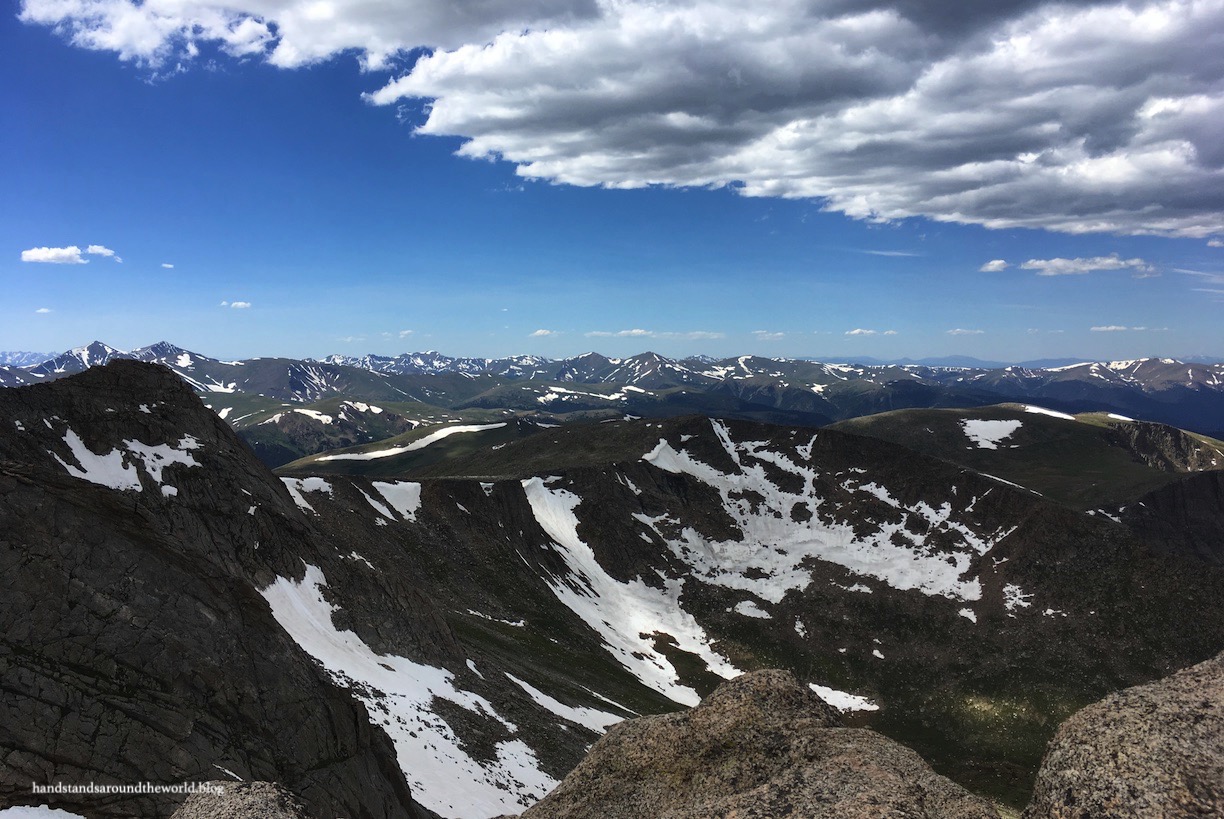
I followed the trail up to the ridge of Mount Spalding. The path was usually visible but when it wasn’t, rock cairns marked the way. This is a class 2 hike, meaning some scrambling is required. For me, as a shorter person, the hardest moves were in this section. In particular, the right photo below was challenging. I know it looks like a jumble of rocks, but it was, in fact, the trail.


Speaking of the trail… it is not always intuitive. Some amount of route-finding is necessary on this hike. Route-finding is a skill that requires practice and preparation. To prepare, I had downloaded the complete route description and photos from the 14ers.com app and saved it for offline use. I’d also spent about 20 minutes studying the route the day before. This, combined with carefully searching for every cairn, kept me on the correct route.


Once reaching the ridge, the trail leads to the summit of Mount Spalding at 13,842 feet (4219 m). From here, the trail descends 250 ft (76 m) to the saddle between Spalding and Blue Sky. After a brief somewhat flat section, I began to regain the elevation I’d lost… and then some. I was still over 1 mile (1.6 km) from the summit of Blue Sky, and yet I had already crested 14,000 feet (4267 m). The remainder of the trail is an alternating class 1 and 2 route that undulates just below the ridge of Blue Sky. Some of the rocks were wet from the previous night’s rain; it was slow going to ensure I didn’t slip. I was glad to have my hiking poles. I’m also not above butt scooting when necessary. I don’t care if I look like an idiot. Safety first.


After nearly two hours of hiking, I reached the summit trail… a series of switchbacks that climbs from the summit parking lot to the actual summit of Mount Blue Sky. Much to my surprise, the trail was empty. So was the summit. There were a couple cars in the parking lot, but none of the people ventured up the trail, so I had the summit of Mount Blue Sky entirely to myself for 15 minutes! I couldn’t believe it!


(At the time of my hike, the mountain was named Evans after former Colorado governor John Evans, who endorsed the Sand Creek Massacre and was later forced to resign for the role he played in it. After a years-long effort, and with the input of the local Cheyenne and Arapaho tribes, the mountain has been renamed Mount Blue Sky.)
Unfortunately, the clouds still hung low in the sky. This made me nervous, as I could no longer see any thunderstorms that might be building. The forecast was for storms around noon, and it was only 8:00am. But mountain weather is fickle and lightning is not to be messed with… so after 15 minutes on the summit, I began my descent.
It had taken me two hours to reach the summit and it took slightly less than that to get back to the car. Class 2 terrain is just not conducive to speedy hiking. By the time I was back to Summit Lake, the sun was peeking through overhead… but the clouds behind me were dark and grey and ugly. I was glad to be off the summit.


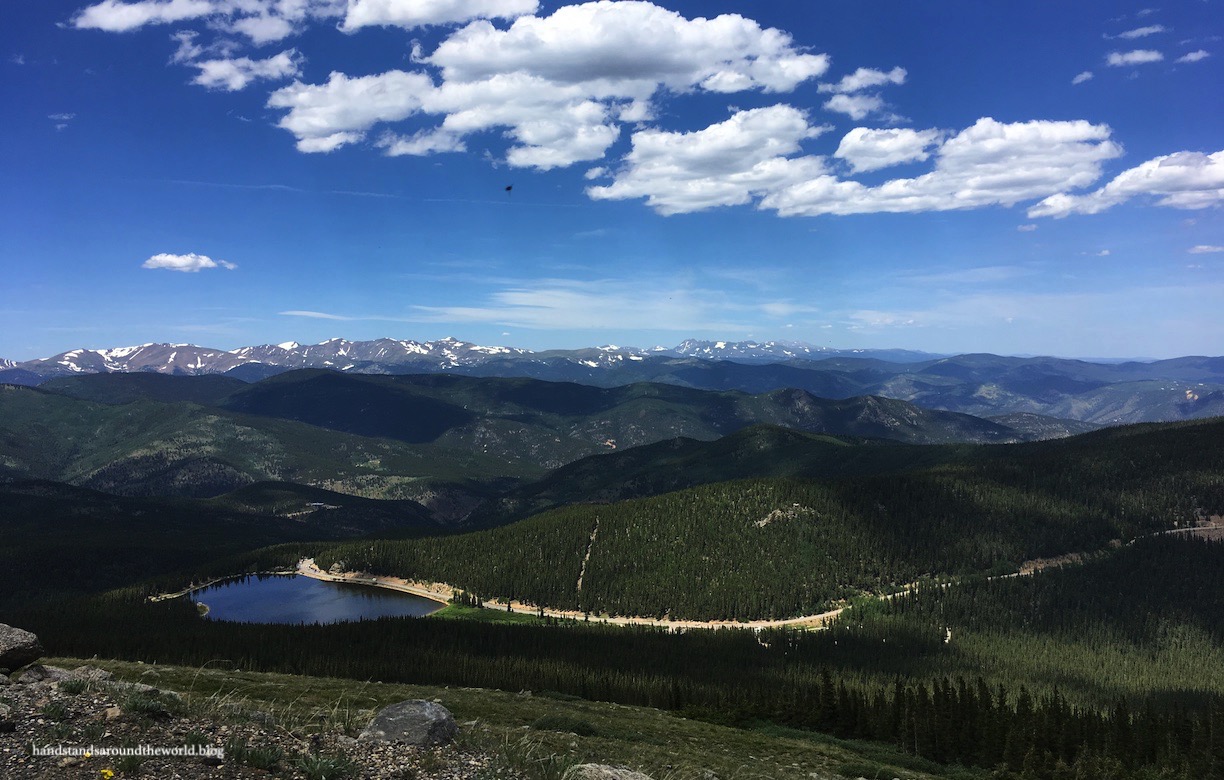
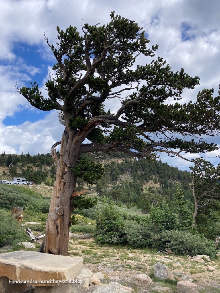
My day wasn’t over quite yet, though. About halfway up the Mount Blue Sky Highway is the Mount Goliath Natural Area, home to a grove of bristlecone pines. These resilient trees grow in very harsh environments, yet can live for over 2000 years thanks to special adaptations such as an extremely slow rate of growth and their ability to go dormant for extended periods of time. They’re pretty amazing trees! And the ones at Mount Goliath happen to be the northernmost stand of bristlecone pines in North America. The Mount Goliath Natural Area was created to study and protect them. There’s a small visitor center here, as well as a short trail through the pines. It was a nice leisurely stroll as a cool down after my hike.


And then I had to brave the remainder of the Mount Blue Sky Highway. I’m glad I summited Blue Sky. I love looking up at it and knowing that I’ve been there. Plus, I’m now one mountain closer to my goal of summiting all of Colorado’s 14ers.
But I’m never ever driving that road again.
The Important Stuff:
- Getting there: Mount Blue Sky Highway/Scenic Byway (CO Highway 5) begins at Echo Lake Park and climbs 14 miles (22.5 km) to the summit. It’s narrow, curvy, steep, exposed, and probably more terrifying than anything you’ve ever driven. Be sure you are comfortable with these things before committing. There are very few places to turn around.
- Season: the road is closed from approximately October – Memorial Weekend. It may also close for short periods of time during the summer due to poor weather. Always check before setting out.
- Fees and passes: timed-entry reservations are required and must be made in advance. Reservations allow you to enter Mount Blue Sky Highway within a 2-hour window during a 3-day period. Once in, you can stay as long as you want. Cost ranges from $7-$17 depending on which areas you want to access; purchase the permit that matches what you want to do. America the Beautiful passes are accepted, but you still need a timed-entry reservation (you’ll be asked to show both at the entrance station, or you’ll need to print and display both on your dashboard if you arrive prior to 8:00am)
- Hiking: from the summit parking lot, it’s only 1/4 mile (0.4 km) and 134 vertical feet (41 m) to the summit. From Summit Lake, it’s 6 miles (9.6 km) and 2140 vertical feet (652 m) round-trip to reach the summit… relatively “easy” for a 14er, but still a challenging hike that requires some route-finding
- Where to stay: there are many camping options in the surrounding national forest and other lodging options nearby in Denver, Idaho Springs, and Echo Lake Park. However, there is nowhere to stay overnight along Mount Blue Sky Highway
- Food: if you’re looking for a place to stop for pizza and/or beer on the way home, I highly recommend Beau Jo’s in Idaho Springs
- Other: although the mountain goats and bighorn sheep here are clearly accustomed to people and hang out near the road and trails, please don’t approach them. They are still wild animals and will defend their territory and their young. We saw a mother mountain goat lunge at someone who got too close

I was so relaxed when I started reading your post and love the photo of the big horn sheep – never saw them before! But then you had my heart in my throat … oh my, the road up the mountain looks terrifying (and I do have a fear of heights)! But then I could breath again when I saw the stunning sunrise colours. And I had to smile (slightly) at that “jumble of rocks” that is the actual path … we have encountered some of these on our hiking trails and it’s crazy to think you have to negotiate your way up (or down) these rocks! You had such great views from the top – well done on reaching the summit of Mount Evans … and that you made it down that mountainous road!
LikeLiked by 1 person
Ah yes, I do remember reading about some of your very rocky and challenging hikes. At least the views made it worth it.
LikeLike
Congratulations, that’s a biggie! I’ve done some hiking along the sides of Evans (soon to be Blue Sky), but never to the top. I have unfortunately made that drive many times, taking visitors up, and hating it. But the goat herd at the top make it worthwhile.
LikeLiked by 1 person
Glad I’m not the only one who hates that road!
LikeLiked by 1 person
Congrats on a true 14er summit! The bristlecone pines are interesting looking trees, very hardy! Maggie
LikeLiked by 1 person
Butt-scooters unite! Well done. Hope to do Evans myself one day. Four hours round trip sounds very doable. Thanks for the trip report.
LikeLiked by 1 person
What a magnificent area, wow!!!
LikeLiked by 1 person
I love these mountain goat photos, they are such rough looking animals.
LikeLiked by 1 person
Yeah, they get really shaggy looking in early summer when they shed their winter coats.
LikeLiked by 1 person
Glad to see you really weren’t alone. Pudgey was with you. Great trip and story but be careful with that hiking alone on these types of trails.
LikeLiked by 1 person
I only hike alone in trails I know are safe to do solo. There were other people around and I had phone service most of the time.
LikeLike
Thank you, Diana, for sharing your spectacular photos and accounts of your adventures. I feel nostalgic for hiking in Shenandoah National Park in Virginia when I was young. Virginia mountains have green woods and lovely waterfalls but are not nearly as challenging as mountains in the West. My niece belongs to a hiking club in Idaho and sends photos of those rugged mountains. At 73, I enjoy mountain climbing vicariously. 🙂
LikeLiked by 1 person
Oh, I would love to do some hiking in Idaho! It’s such a beautiful state. I’ve never been to Shenandoah but I imagine it’s just beautiful this time of year especially.
LikeLike
To me, waterfalls are the best feature of Shenandoah National Park, but spring wildflowers and autumn leaves also draw big crowds.
LikeLiked by 1 person
Fantastic mountain views! Looks like a hike well worth the climb to the top 🙂
LikeLiked by 1 person
Great hike and photos. The reservation system for Mt. Evans Highway reminds me of Yosemite’s entrance requirements (which, thankfully have ended for the season). My hands were sweating when you talked about driving the Highway. Yikes. Great photos of the sheep, how exciting to see them. And great job on the hike! Cool to be able to look at the mountain every day and know that you’ve climbed it.
LikeLiked by 1 person
Ah yes, Rocky Mtn National Park has entrance requirements as well. It does seem to lessen crowding but can be annoying if you can’t get a permit. And my hands were definitely sweating while I drove!
LikeLiked by 1 person
I LOVE your pictures of all the bighorn sheep. They’re so cute. It’s interesting that the permits are good for three days so you can plan around the weather. I guess that makes the most sense considering you’re in the mountains. Congrats on reaching the summit by foot. What a treat to have it all to yourself for a few minutes.
LikeLiked by 1 person
Thanks! I actually should have done a better job labeling (I’ve fixed it now) because I think it was confusing… the first animal photo is a bighorn sheep. The other two are mountain goats.
LikeLiked by 1 person
Incredibly scenic! I am amazed at how close you got to those bighorn sheep (unless you used zoom on your camera?). All the same, the views from the summit make the unintuitive hike all the more worth it, and it’s incredible that you’re so close to hitting all of Colorado’s 14ers! Can’t wait to read about that when it happens!
LikeLiked by 1 person
Oh I’m nowhere close at all yet! There are 58 14ers and I’ve done 8 of them. I have a long way to go!
And yes, the mountain goat photos were taken with zoom and the bighorn sheep walked right next to the car, so that photo was taken through the window.
LikeLiked by 1 person
Wow!! Congrats on bagging this peak!!! Looks so amazing!
LikeLiked by 1 person
Thanks!
LikeLiked by 1 person
Oh, no, that road is off-putting! We are looking at 14ers for next summer and thought this one would be manageable. I think it would be, but I’m not too excited about the road!
LikeLiked by 1 person
I definitely think you could do this one, it’s relatively straightforward by 14ers standards. Nearby Mt. Bierstadt would be a good candidate too, and the road is much less sketchy.
LikeLiked by 1 person
Fabulous effort and as you say far better to have walked it and ticked it off properly. Butt scooting? Not heard that before. Over here in England some people call it the arse crampon!!
LikeLiked by 1 person
Haha the arse crampon. I love it!
LikeLiked by 1 person
I was there many, many years ago and did the drive to the top. Definitely a bit of a dicey drive! But the scenery made it worth it! ❤
LikeLiked by 1 person
Worth it for sure! Never again, though
LikeLiked by 1 person
What a beautiful hike and you were rewarded with the summit to yourself! I think Jon wouldn’t talk to me for weeks if I picked this hike and made him drive on that road. It reminds me a bit of some of the roads near Lake Tahoe that were a bit sketchy. Well done on completing another 14er!
LikeLiked by 1 person
Hahah yeah, it’s an adventurous drive for sure. Pat has driven it twice and doesn’t seem to mind, so if you guys ever come to CO and want to go up Evans we can have him drive you to the summit 😂
LikeLiked by 1 person
Sounds perfect haha!
LikeLiked by 1 person
Awww that baby bighorn sheep/mountain goat is adorable 🥰 There’s something very satisfying about seeing a peak from your house and knowing you’ve climbed it, and it’s pretty neat that you had the summit to yourself. I don’t think I could bring myself to drive up that road to get there, though. Looks terrifying!
LikeLiked by 1 person
The baby is a mountain goat! Isn’t it so cute? They’re so fluffy! And yeah, I won’t be driving that road ever again.
LikeLiked by 1 person
I don’t think I’ve ever seen such a fluffy goat! Utterly adorable.
LikeLiked by 1 person
So scenic!
LikeLiked by 1 person
Wonderful hike as always Diana – Summit Lake is really beautiful and those views out over it incredible. I’m glad you said you used a zoom lens on the animals as I was thinking god, I hope they didn’t run at her with those horns! haha! 🙂
LikeLiked by 1 person
Hahah yeah, I would never get that close to a wild animal (though some people do sadly, and it often ends poorly). Those horns would hurt!
LikeLike
Wow, what a fantastic hike, Diana, congratulations on reaching the summit! I like your sunrise photo and the views across the various mountain peaks – given how rarely I get up and do that, seeing a proper sunrise necessarily becomes a memorable experience. Or rather, a priceless adventure. Thanks for sharing and have a good day 🙂 Aiva xx
LikeLiked by 1 person
Thanks Aiva! I too tend to miss most sunrises so it’s always nice when you wake up early and are greeted by colorful skies.
LikeLiked by 1 person
I loved this encounters. I have driven but not hiked it. I know what you mean -I live in Colorado Springs and had to climb Pikes Peak years ago, so when I look at it, I know I climbed it.
LikeLiked by 1 person
Oh fun! I haven’t summitted Pikes yet but one day I hope to.
LikeLike